Developers have returned to the Council with additional plans for how they would shore up the slope behind 32–62 Broughton Road in order to make possible the building of 8 new townhouses in a narrow strip of land there (Ref. 15/02335/FUL).
In supplementary comments submitted on 11 January 2016, architects Sir Frank Mears Associates (SFMA) first refer to a series of ‘commissioned images of the site’ which they added at an unspecified time to their original submission of 20 May. These images – comprising 'a view of the proposed development and an aerial view, set in the framework of a picture taken from a drone’ – do not appear to be on the Council Planning Portal, and we are not sure whether any members of the public have seen them.

This shows the slope reconfigured into 2 steps, with one sheer vertical fall of 6 metres and another of about 2.5 metres. Using this structure, the new buildings’ integral strength, restored boundary walls, piling and Cribloc systems would, says SFMA, ‘retain the land’.
The listed building consent application which accompanied that for full planning permission, includes a provision for access to ‘drill down through the fill material on site to assess the needs of the proposed design and the extent of retention measures required to stabilise the land. The information is essential to allow detailed designs to be prepared for a future Building Standards submission’.

SFMA repeats its intention of providing ‘professionally designed areas of appropriate new planting on the site at the top of the slope, and in the verge overlooking the tenement gardens’.
In a further addition, SFMA provides an artist’s impression of how the finished entrance to the site would appear from Broughton Road once boundary walls had been rebuilt.
Queries and misgivings
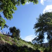
Spurtle has no expert to hand, but the new contextual section strikes us as illustrative rather than technically detailed. We do not understand why the top of the townhouse appears below the level of gardens to the south, when in the elevation submitted on 20 May 2015 as part of the planning application (see here) it was clearly higher.
The artist’s impression is an impression by an artist … not surprisingly, it makes everything look lovely.
The last time we reported on developments around ‘Sandy Hill’ was back in July 2015 (Issue 242). At that stage, around 117 people (including the New Town & Broughton Community Council) had objected to the application.

The current planning system which allows developers to continue ‘privately’ explaining and refining their submissions – long after the public has been engaged and at a point when it has no further opportunity to comment – will strike very few lay observers as transparent or fair.
-----------------------------------
 Bob Murphy Should be replanted with native woodland then left well alone. Ridiculous site to even contemplate building on, especially when there are many others suitable for development in and around the city. It appears to be another case of avarice trumping sensibility.