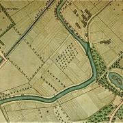
Have you noticed the increasingly uneven appearance of St Mark's Park? What was, a few years ago, a fairly flat surface with one or two notable humps between the plantation and cherry-tree avenue has, by imperceptible stages, become noticeably lumpier. Spurtle investigated.
The good news is that – contrary to local fears – the site is not in the process of conversion to a links golf course and luxury development following purchase by Donald Trump.
Earlier in 2011, engineers were considering temporary compound sites for machinery involved in the forthcoming Water of Leith Flood Defence works. One such site was St Mark's Park, and In March the City of Edinburgh Council ordered an archaeological survey of the area in advance.
CFA Archaeology Ltd dug trenches covering nearly 10 per cent (495 sqm) of the site down to about half a metre. At each end they dug down to a metre, with some of the trenches focused on pre-existing 'hollows and scoops'.
[img_assist|nid=2206|title=|desc=|link=node|align=right|width=200|height=136]
The aim was to establish the 'presence or absence, location, extent, date and character, condition, significance and quality of any surviving archaeological remains within the development site; and to establish their significance and vulnerability to the proposed development'.
The results are both interesting and disappointing. No archaeological remains or deposits were found, or would be at risk from the proposed compound. Diggers could not even find the natural subsoil.
Instead it emerged that ground had been significantly built up above the level of the original allotments and parkland shown in 19th and early 20th-century maps. Anecdotal evidence suggested large-scale dumping of ash on the site in the early 1950s, and large quantities of refuse were found (including glass bottles clearly dating from that period).
Occasional animal bones were also discovered, and, rather disgustingly, a decomposed pig carcass.
[img_assist|nid=2205|title=|desc=|link=node|align=right|width=200|height=169]
By Spurtle's estimation (partially based on photos from the late 1940s which we do not have permission to reproduce), the current ground level at this side of this park could be 6 feet or more above the original. Consider it in comparison to the area sloping down towards the Gormley statue, or to the football pavilion, or to the scrubby section approaching the weir to the north-east; all of which are substantially and suddenly lower.
None of this will come as too much of a surprise to locals, some of whom remember the park in its grim, ashy past. Why it should have become bumpier of late is unclear, but a Parks official suggests it may be due to settlement of the backfilled trenches. Another source points to unusually heavy rain and snow during the last two years.
The full archaeological report is attached at the foot of this page. The maps shown on this page are, in order: (1) Alfred Lancefield, Johnston's Plan of the City of Edinburgh (1851; repeated below); John G. Bartholomew, Bartholomew's Plan of the City of Edinburgh with Leith (1891); J.G. Bartholomew, Plan of Edinburgh and Leith, from the Survey Atlas of Scotland (1912). Click on each to enlarge.
[img_assist|nid=2207|title=|desc=|link=node|align=middle|width=640|height=454]