After two days of heavy-ish rain, and with more on the way, the Scottish Environment Protection Agency this afternoon issued a flood warning for Edinburgh and the Lothians.
It covers the area as a whole and does not specify Stockbridge, Warriston or Bonnington as being at particular risk.
'The persistent rain forecast throughout Monday has the potential to result in localised disruption and flooding to low lying land and roads, via surface run off and small watercourse sources.' Advice and information are available on Tel. 0845 988 1188.
Spurtle walked the Water of Leith from Dean Bridge (right) to the weir below Redbraes at lunchtime today. Here's what we saw.
1. Stockbridge from the bridge looking east. The contractor's ramp is under water.
[img_assist|nid=3581|title=|desc=|link=node|align=left|width=501|height=640]
2. From the Bell Place Bridge looking west.
[img_assist|nid=3582|title=|desc=|link=node|align=left|width=480|height=640]
3. Residents at this Reid Terrace colony are becoming better and better acquainted with floating neighbours.
[img_assist|nid=3585|title=|desc=|link=node|align=left|width=441|height=640]
4. Looking west from the Tanfield Bridge. The footpath looks likely to be covered soon.
[img_assist|nid=3586|title=|desc=|link=node|align=left|width=480|height=640]
5. From the bridge at Canonmills, looking west. The section of floodwall below the restaurant appears ineffective, unless it is only intended to shield the building from debris.
[img_assist|nid=3587|title=|desc=|link=node|align=left|width=480|height=640]
6. Looking east from Canonmills, this section of the new defences is working well.
[img_assist|nid=3588|title=|desc=|link=node|align=left|width=480|height=640]
7. Further downstream, however, where the wall is incomplete the results are unsurprising. The footpath along Warriston Road is closed from Boat Green eastwards, because of flooding say the signs. We saw no evidence of this.
[img_assist|nid=3589|title=|desc=|link=node|align=left|width=480|height=640]
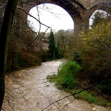
8. Downstream from the bridge at Warriston Junction, the river was at its fastest.
[img_assist|nid=3590|title=|desc=|link=node|align=left|width=640|height=480]
9. Looking upstream from St Mark's Bridge: the contractor's ramp is again flooded.
[img_assist|nid=3591|title=|desc=|link=node|align=left|width=480|height=640]
10. Powderhall Rigg opposite St Mark's Park looks safe enough.
[img_assist|nid=3592|title=|desc=|link=node|align=left|width=640|height=480]
11. The weir below Redbraes was a hissing cauldron, but good for fishing.
[img_assist|nid=3593|title=|desc=|link=node|align=left|width=480|height=640]